


Ship Radar - Ship Positions

Perihal Ship Radar - Ship Positions
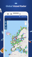
🌟 All vessels live on a map 🌟
➡️ You have the option to choose between 4 map types: Standard map, Simple map, Satellite map or OpenStreetMap
➡️ Every vessel type is marked in a specific color
➡️ You can explore plenty of different vessel types: Fish carriers, Crude Oil Tankers, Fishing Vessels, Other Tugs / Special Crafts, Bulk Carriers, Fire Fighting Vessels, Service Vessels, Passenger Ships, Training Ships, Yachts and much, much more
➡️ Besides vessels, the map contains ports and other locations
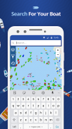
🌟 Search option 🌟
➡️You also have the option to search for specific vessels by IMO number or MMSI, ports, seas or other locations.
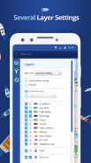
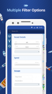
🌟 Filter option 🌟
➡️Sort out specific vessel types, so that you only get to see what you want to see.
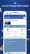
🌟 Vessel information 🌟
➡️ Get various pieces of vessel information by tapping on a vessel symbol such as speed, course and current status. You also get to see a picture of each vessel.
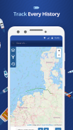
How does it work?
---------------------------------
We are using AIS data to provide you most accurate information. If you want to track vessels you just have to tap on "Start ship radar"
🌟 Semua kapal tinggal pada peta 🌟
➡️ Anda mempunyai pilihan untuk memilih antara 4 jenis peta: Peta Standard, peta Mudah, Peta Satelit atau OpenStreetMap
➡️ Setiap jenis kapal ditandakan dalam warna tertentu
➡️ Anda boleh meneroka banyak jenis kapal: pembawa Ikan, Tangki Minyak Mentah, Vesel Penangkapan Ikan, Lain Tunda / Crafts Khas, Carriers Bulk, Kebakaran Kapal, Vessels Service, Kapal penumpang, Kapal Latihan, Kapal Layar dan banyak lagi
➡️ Selain kapal, peta mengandungi pelabuhan dan lokasi lain
🌟 🌟 pilihan Carian
➡️You juga mempunyai pilihan untuk mencari kapal tertentu dengan jumlah IMO atau MMSI, pelabuhan, laut atau lokasi lain.
🌟 🌟 pilihan Filter
➡️Sort keluar jenis kapal tertentu, supaya anda hanya dapat melihat apa yang anda mahu lihat.
🌟 🌟 maklumat Kapal
➡️ Dapatkan pelbagai potongan maklumat kapal dengan mengetik pada simbol kapal seperti kelajuan, kursus dan status semasa. Anda juga dapat melihat gambar setiap kapal.
Bagaimanakah ia berfungsi?
---------------------------------
Kami menggunakan data AIS untuk memberikan anda maklumat yang paling tepat. Jika anda mahu untuk mengesan kapal anda hanya perlu tekan pada "radar kapal Start"
Ship Radar - Ship Positions - Versi 1.1.9
(15-12-2020)
Ship Radar - Ship Positions - Maklumat APK
Versi APK: 1.1.9Pakej: com.sawischa.shipfinderVersi Terkini Ship Radar - Ship Positions
Versi lain


 3.55
3.55


Aplikasi dalam kategori sama


